 Approximate location
The proposed Blue Mountains Wildlife Park is located at the foot of Bodington Hill, Wentworth Falls on the Great Western Highway.
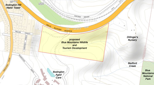 Map of proposed Wildlife Park and surrounds
(click image to see a larger version)
These are known as "zombie DAs". In theory, if the conditions of the original development approval are met, then it can be built.
In early 2021 a proposal for a new and larger Blue Mountains Wildlife Park gained State Significant Development Status. This means that assessment of the proposal is taken out of Council’s hands. The proposal also included a 56-room hotel.
In March 2021, the Department of Planning issued the Secretary’s Environmental Assessment Requirements (SEARs), which identifies what information needs to be provided in an Environmental Impact Statement (EIS). The EIS needed to be completed and lodged with a development application (DA) within two years - later extended to July 1 2023.
In July 2023 time expired on the previous proposal for a hotel and zoo development on the site. The developer didn’t lodge the Environmental Impact Statement (EIS) and Development Application (DA) by the due date and so the proposal lapsed. This meant that if the developer wanted to proceed with the project as a State Significant Development (SSD) there would have to be a new application to the NSW Department of Planning for a Secretary’s Environmental Assessment Requirements (SEARs). The SEARs outlines the issues to be addressed in the EIS. Once the SEARs is issued, the developer has 2 years to lodge the EIS and DA..
The Department of Planning has issued new Secretary’s Environmental Assessment Requirements (SEARs) for the Blue Mountains Wildlife Park. You can access this and the accompanying government agencies’ advice (including the Blue Mountains City Council’s) at https://www.planningportal.nsw.gov.au/major-projects/projects/blue-mountains-wildlife-park.
The SEARs tells the developer what issues need to be addressed and what information needs to be provided in the Environmental Impact Statement (EIS). The developer now has 2 years to lodge the EIS and Development Application. These will then go on public exhibition at some point.
As part of developing the EIS the developer is required to conduct community consultations. So keep an eye out for notifications in the Gazette, notices in shops and on community noticeboards, and in the Society’s weekly E-News bulletin if we get enough notice.
In mid-January 2025, Society members were notified that a new application for SEARs had been lodged with the Department of Planning. The documentation can be found on the Department’s major projects website: https://www.planningportal.nsw.gov.au/major-projects/projects/blue-mountains-wildlife-park
The ‘new’ hotel and zoo proposal As the project Scoping Report says, the new proposed SSD remains largely unchanged from that for which SEARs was previously issued in 2021. The ‘new’ development comprises:
- A main entrance building comprising entry/exit, ticketing area, gift shop and café;
- Internal, external and aquatic animal exhibits across several enclosures of varying design for a range of native and exotic animals;
- An animal hospital / rehabilitation clinic;
- An outdoor flora and wildlife walking trail, with associated structures such as for boardwalks, a suspension bridge, and a viewing platform;
- An animal boarding facility;
- A high ropes adventure course, toboggan track, zip-line, and a chairlift;
- 5-star hotel accommodation with ground floor restaurant and bar; [comprising 4 hotel buildings and 57 rooms over 3 levels in 3 of the hotel buildings, see Appendix B]
- ndigenous arts and education centre;
- Auditorium for public, community events and education;
- Food and beverage units, including food kiosks throughout the park;
- Site-wide security and animal protection fencing;
- Associated landscaping works including picnic areas, gardens, aerial walkways, bushwalks, graded pathways, wetlands and waterways;
- Upgrade of the existing driveway on the Great Western Highway, which will remain as left-in / left-out; and
- Internal roads, car parking facilities for private motor vehicles, buses and coaches, and loading dock area.
So what’s new in this ‘new’ proposal?
There are some major changes:
• No traffic lights at the site entry
Transport for NSW did not support the previously proposed new signalized highway intersection at the site entry to cater for visitors arriving from the west and departing to the east. The new project proposes using the existing left-in / left-out access from the Great Western Highway to access the site:
- “For vehicles arriving from the west, it will be necessary for the vehicle to proceed east bound past the site access driveway for approximately 1.7km, to make use of existing turn round facilities at Genevieve Road, Bullaburra. These arrangements have already implemented for bus services.
- For the vehicles departing to the east, it will be necessary for the vehicle to initially turn left and proceed west-bound on the Great Western Highway towards Wentworth Falls. Turn around arrangements are available at Tablelands Road (non-signalised) or Old Bathurst Road (signalised). Buses and coaches would be expected to turn around at the Old Bathurst Road signalised intersection, which includes a dedicated right-turn lane.” (p.32 Scoping Report)
• Car parking moved underground, beneath the hotel and wildlife buildings
In previous versions of the development proposal, coach and car parking was located on the surface at various points. What is now proposed is some 300 vehicle parking spaces, almost all of which will be located in an underground carpark beneath the hotel and wildlife buildings. Coach/bus parking will still be situated on the surface along the highway frontage.
• No crocodiles, at least in these new preliminary plans
Indoor and outdoor animal exhibits remain, as do the ‘free range’ and enclosed animal exhibits in the eastern half of the site. Indicative animal exhibits still include reptiles (including lace monitors), aquatic animals, wallabies, kangaroos, wombats, koalas, dingoes, cassowaries, Tasmanian Devils, quokkas, echidnas, emus, nocturnal house and now Little Blue Penguins.
• Additional recreational activities
A chairlift and toboggan run/track have now been added to the high ropes course and zip-line in the C2 Environmental Protection zone in the eastern half of the site.
• Impact of highway access on traffic flow and safety in a high-speed, high-volume traffic environment on a steep hill; eastbound vehicle ‘turnaround’ arrangements, especially at the dangerous Tableland Rd intersection, are of particular concern.
• Encroachment of development into the C2 Environmental Conservation zone. The hotel buildings, pool and amphitheater still encroach fully or partially into the C2 zone at the western end of the site; ‘free range’ exhibits, animal enclosures and holding yards, and recreation structures (chairlift, toboggan track/run, high ropes course, zip-line and associated infrastructure) are located in C2 zone in the eastern half of the site.
• Environmental and visual impact of vegetation removal on the western half of site for excavation, terracing, hotel buildings, outdoor exhibits, landscaped parkland/picnic areas, internal roads and Asset Protection Zone (APZ). The Asset Protection Zone (requiring vegetation clearing) covers the entire western half of the site including the whole of the C2 Environmental Conservation zone, and intrudes into the property to the south. If the site is cleared of vegetation to the western boundary for the APZ, Bodington Hill could be cleared to just past where the gabion basket stone wall starts.
• Threat to the hanging swamp and creek on the site and the national park downstream from:
- interference with groundwater flow feeding the swamp and creek due to deep excavation for underground carpark and construction uphill;
- sediment pollution from loss of vegetation cover in the development area, construction on steep slopes, clearing for the Asset Protection Zone (western half of site); and from vegetation removal and soil disturbance in the ‘free range’ and enclosed animal exhibits and for recreational activities (eastern half of site);
- water pollution (including nutrient pollution) and potential weed spread from unmanaged and untreated rainwater runoff through ‘free range’ and enclosed animal exhibits in the eastern half of the site.
• Visual impact in ‘Land Between Towns’ Protected Area through:
- vegetation/tree clearing for buildings, landscaped parkland/picnic area, outdoor animal exhibits and Asset Protection Zone affecting the whole western side of the site and potentially up the hillside;
- over-height (13m) hotel buildings located at the highest (western) end of the site in an 8m maximum building height area.
• Bushfire risk. Bushfire prone land Vegetation Category 1 (highest bushfire risk) covers the entire site. History of fires in this area. Concerns about animal and people evacuation.
• Impact on adjoining residents and aged care facility. Potential 24/7 noise and light pollution from hotel operations, visitor activity and outdoor animal exhibits; visual intrusion from hotel buildings.
It is anticipated that the Department of Planning will issue a new SEARs to the developer in mid-February. The SEARs and related documents will be posted on the project website. The developer then has 2 years to lodge the EIS and DA. These will then go on public exhibition at some point.
State Significant Developments are processed, assessed and approved at state government or Independent Planning Commission level. The Council has no role other than advising the Department of Planning on SEARs requirements, project amendments etc. and making a submission to the public exhibition.
We acknowledge the traditional custodians of this land
the Darug and Gundungurra people
and pay respect to their Elders past and present.