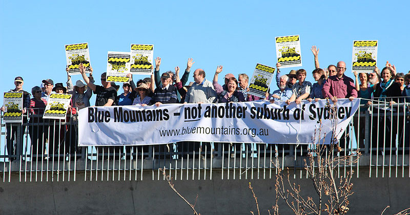
 Blue Mountains - not another suburb of Sydney (Rob Linigen)
View the government’s proposal: "Explanation of Intended Effect: Changes to create low- and mid-rise housing"
Here's the Society's submission
Here's the Blue Mountains City Council's submission (4.5MB)
What is proposed?

The government proposes establishing an 800m ‘precinct’, measured from a railway station and boundary of a ‘town centre’ (see below), to increase housing in the Greater Sydney, Newcastle and Wollongong regions. Within these precincts housing density will increase dramatically, primarily by allowing increased residential building heights, often up to 6 storeys.
The government also proposes increasing housing density in all R2 Low Density Residential zones across the state.
In the Blue Mountains these proposed changes will mean:
- Precincts:
- Station precincts are defined as 800m around a railway station. Almost all mountains towns have a railway station so they will have a station precinct.
- Town centre precincts are defined as 800m from the outside boundaries of land zoned E2 Commercial Centre or land zoned E1 Local Centre. Most mountains towns have land zoned either E1 or E2 (i.e. commercial/shopping centres). An E1 Local Centre only qualifies as a town centre precinct if it contains a wide range of frequently needed goods and services such as full line supermarkets, shops and restaurants. Under these criteria Winmalee qualifies as a town centre precinct.
- Although most mountains towns have a station precinct and a town centre precinct, because they have both a railway station and E2 or E1 (shopping centre) zones, some towns only have a station precinct. These towns are Medlow Bath, Bullaburra, Linden, Valley Heights.
- In larger towns like Katoomba and Springwood, which have both a station precinct and a large town centre precinct, the combination of station and town centre precincts can create a ‘super-precinct’.
In the case of Katoomba, the 800m station precinct centred on the railway station combines with the 800m town centre precinct (measured from the outer boundary of the large E2 zone in Katoomba’s commercial centre) to create a ‘super-precinct’. This ‘super-precinct’ spreads from Fitzgerald St in North Katoomba, to well beyond The Gully to the west of the shopping centre, down to Goyder Ave in the south (where Katoomba Falls Rd starts), and just about the entire area east of Katoomba St to around Govett St on the border of Leura.
Note that not all areas within the precincts are affected by the proposed changes, only specific zones.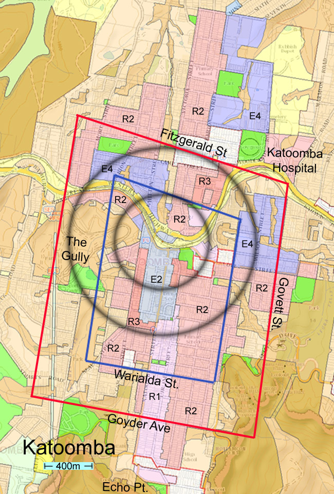
Katoomba
The black circles are 400m and 800m radius from Katoomba Station.
Katoomba town centre is shown in light blue. The blue rectangle is 400m from the town centre; the red rectangle is 800m from the town centre. All measurements are approximate.What will happen within the precincts?
- Up to 6-storey (21m) blocks of flats will be permitted in the E1 Local Centre, E2 Commercial Centre, R1 General Residential and R3 Medium Density Residential zones within 400m of railway stations and town centres.
- Up to 6-storey (21m) shop-top housing will be permitted in R1 General Residential, E1 Local Centre and E2 Commercial Centre zones within 400m of railway stations and town centres
Note that there is a large R1 General Residential-zoned area running down the eastern side of Katoomba St (and a few blocks east) between Waratah St and Echo Point. The 800m town centre precinct measured from the southern edge of the E2 zone at Waratah St extends down to Goyder Ave. The first 400m of the town centre precinct runs from Waratah St to just past Warialda St. The above provisions could therefore see 6-storey blocks of flats and shop-top housing built on the eastern side of Katoomba street (and the blocks behind) between Waratah St and Warialda St, and 4-5 storey blocks of flats between Warialda St and Goyder Ave (see next point). - 4-5 storey (16m) blocks of flats will be permitted in the E1 Local Centre, E2 Commercial Centre, R1 General Residential and R3 Medium Density Residential zones between 400-800m of railway stations and town centres.
- 2-3 storey (9.5m) medium density residential buildings (manor houses, multi-dwelling houses, rows of terrace houses or townhouses) will be permitted in R2 Low Density Residential zones in the precinct.
Example of a town centre precinct: Winmalee.The provisions above mean that 6-storey residential flat buildings or shop-top housing could be built in Winmalee’s shopping centre (the E1 zone and adjoining R3 zone). 2-3 storey medium density housing could be built in the current R2 Low Density Residential zones in the town centre precinct (i.e. within 800m of the boundary of the E1 zone/ shopping centre). That’s the entire residential area around the Winmalee shopping centre. Additionally, all R2 low density residential areas outside the Winmalee town centre precinct will also be affected (see below).
- Outside the precincts
- 2-3 storey (9.5m) dual occupancies (attached or detached) will be permitted in R2 Low Density Residential zones, and on smaller blocks (see later).
This provision impacts just about every town in the Blue Mountains, with particularly large swathes of R2 Low Density Residential zoned areas located outside the precincts in Katoomba, Faulconbridge-Springwood and Blaxland.
- 2-3 storey (9.5m) dual occupancies (attached or detached) will be permitted in R2 Low Density Residential zones, and on smaller blocks (see later).
These increased building heights and densities inside and outside the precincts in certain zones are over and above what is currently permitted in Local Environmental Plans. These new building heights and densities will be mandated through ‘non-refusal standards’.
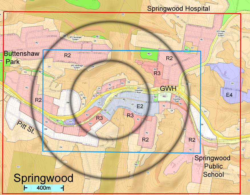
Springwood
What are ‘non-refusal standards’?
A ‘non-refusal standard’ means that approval can’t be refused if the development complies with the standards. It is unclear from the documentation available who, exactly, assesses this and grants approval – Council or an accredited certifier (i.e. person paid by developer) – though it seems Council will have some role to play.
The ‘non-refusal standards’ include:
- reduced minimum lot sizes (MLS). Council is currently awaiting approval from the Department of Planning for its new proposed Minimum Lot Sizes, including for dual occupancies in residential (‘R’) and other areas. The Council proposes 1000 m2 MLS for dual occupancies. The government’s proposed mandatory MLS for dual occupancies in all R2 Low Density Residential zones across the state is 450 m2. That’s half the current and proposed MLS for dual occupancies in the Blue Mountains.
- increased building heights. While residential flat buildings and shop-top housing are currently permitted in the town centres under our Local Environmental Plan, their height is limited. For instance, buildings along Main St and Katoomba St are generally limited to 11m. Under the government’s proposal it would be 21m. That’s double the current maximum height allowed. (See heritage issues later.)
NOTE THAT, due to the government’s new in-fill affordable housing provisions, residential flat buildings and shop-top housing in these precincts qualify for a floor space ratio (FSR) bonus of 20-30% and a height bonus of 20-30% if at least 10-15% of the gross floor area of the building is used for affordable housing. That means more floor space allowed plus an additional storey! - increased Floor Space Ratios (FSR) which will allow more floor space on sites in the precinct. For instance, buildings along Main St and Katoomba St are generally limited to a FSR of 1.5:1. Under the government’s proposal it will be 3:1 for shop-top housing and residential flat buildings. That’s double the floor space currently allowed.
- tokenistic landscaping ‘targets’. The proposed landscape “targets” are only concerned with planting trees, mostly only 1 or 2 depending on the size of the property, and gaining around 20% tree canopy cover. This contrasts with current local planning provisions to replace vegetation lost with a range of plants, including trees and NOT invasive species.
This also varies from our local concern to maximise ‘pervious’ areas. At least 40% of most residential sites are required to be free of hard surfaces and vegetated.
It is very difficult to compare our current local standards with these proposals, but overall it looks like a significant reduction in vegetated areas.
What do these reforms mean for Heritage Conservation Areas and Heritage Items in these precincts?
Heritage Conservation Areas will not be protected from development under the proposed reforms. On page 28 of the Explanation of Intended Effect it is clearly stated that the non-refusal standards will over-ride Local Environment Plan heritage conservation and environmental protections if there is a conflict between them. This essentially means that development within the precincts that meets the ‘non-refusal standard’ doesn’t have to take any notice of any heritage and environmental protections that may apply to the site.
Protection for specific Heritage Items e.g. particular shops, homes and sites is unclear but is likely to not be affected by the proposed reforms.
How do these reforms relate to the 2020 Low Rise Housing Diversity Code (LRHDC)?
The LRHDC applies across NSW, including the Blue Mountains, in residential ‘R’ zones (R1, R2, R3). The LRHDC allows certain kinds of housing – dual occupancies and medium density housing (manor houses and terraces) – to be built under fast track development approval (bypassing Council) if they comply with certain minimum standards.
The LRHDC will still apply in these ‘R’ zones inside and outside the precincts.
Unlike the proposed housing reforms, Heritage Conservation Areas and Heritage Items are excluded from the LRHDC.
Fire threat and flooding provisions
Proposed developments within the precincts must still meet all relevant local planning controls in Local Environment Plans and Development Control Plans relating to flooding provisions and development on land that's bushfire prone. The Rural Fire Service’s Planning for Bushfire Protection will still apply.
What will this mean for housing targets for the Blue Mountains? Will they be raised after the current targets expire in 2026?
No-one knows.
When will the reforms start?
There is conflicting information about this. The proposed changes could take effect from April or June 2024.
It is highly questionable whether this proposal will achieve its aim of making more housing available and affordable … or just create more opportunities for investors, and more empty apartments to add to the significant number in some areas of the Blue Mountains (for example some streets in Blackheath have more than 50% of houses vacant all year).
Here are some suggestions that you may wish to use in objecting to this proposal:
1. Objection on planning grounds
The rush to provide at least 314,000 new homes by 2029 has led to proposed housing reforms that represent ‘worst practice’ development intensification by decree, not planning. The proposed reforms will trash over 20 years of careful planning at the local and state level.
- The Blue Mountains City Council and community worked hard to ensure that the environmental protection measures developed after the declaration of the Greater Blue Mountains World Heritage Area in 2000 were incorporated into Local Environmental Plan 2015. These measures were designed to manage runoff, weeds and other impacts from urban areas on the surrounding natural environment and World Heritage Area. All these environmental protections including, critically, the requirement for developments to meet stringent stormwater controls will be overridden by the proposed ‘non-refusal’ standards. This will have an adverse impact on the quality of water flowing into the World Heritage Area and Sydney’s drinking water catchment, for example.
- The Council’s Local Housing Strategy (2020) and housing targets to 2026, endorsed by the previous NSW government, were based on a careful analysis of factors such as environmental constraints and bushfire risk. The housing intensification proposed by the reforms overrides the Blue Mountains housing strategy and targets.
- The Greater Sydney Commission’s regional plan A Metropolis of Three Cities (2018) and Western City District Plan (2018) classified the Blue Mountains as a Metropolitan Rural Area (MRA). The MRA classification recognizes the mountains’ unique location in a World Heritage Area and the constraints on development, including bushfire risk. In the NSW Government’s current planning framework MRAs are regarded as areas that are unsuitable for urban expansion and dormitory suburbs. The housing intensification proposed by the reforms ignores the Blue Mountains’ classification as an MRA.
The NSW Government’s proposed housing reforms, delivered through decree, are a slap in the face to local government planners and communities and break planning agreements that were years in the making.
Request that this proposal is withdrawn and call for strategic planning in each area, rather than this simplistic “one size fits all” remedy.
2. Fire threat
Although any development under these proposed housing reforms will still have to meet current bushfire planning controls and regulations, the proposal ignores the danger of putting more housing in bushfire prone areas.
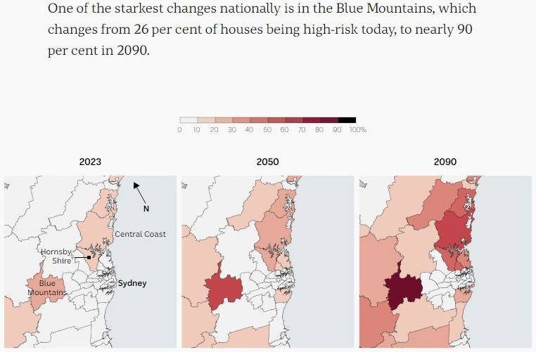
According to recent research conducted by Finity Consulting, the Blue Mountains faces a massive increase in the number of homes exposed to high bushfire risk due to climate change. Today it is 26%; by 2090 it will be 90%. It is grossly irresponsible to put more people in harm’s way through these proposed planning reforms.
Many railway stations and towns have bushland reserves, national parks, or private bushland (C2 zone) within the 800m precinct designated for high density residential buildings. For example, around the Springwood local centre (area zoned E2) a huge number of residential buildings will be permitted all within a short distance of the Fairy Dell Reserve. This potentially puts large numbers of residents at risk.
3. Environmental Safeguards Overturned
These proposed reforms will mostly override local planning controls to safeguard the environment. Despite of the claim in the Explanation of Intended Effect document (EIE pp.10-11) that this infill development will “protect important habitat and biodiversity from an encroaching urban fringe”, in the Blue Mountains it will lead to:
- loss of bushland
- reduction in the quality of water that enters creeks
- soil erosion as buildings can be permitted on steep slopes, and
- loss of protective buffers around significant vegetation communities.
⮚ Loss of bushland
It expands the footprint of development which will lead to loss of bushland for the buildings and more clearing for fire protection (Asset Protection Zones). Bushland even in urban areas has become increasingly important habitat for wildlife, particularly during and after bushfires.
Reduced lot sizes to 450 sq m for dual occupancy will mean more environmental damage due to:
- Inadequate space for stormwater control structures
- More clearing of bushland because of Asset Protection Zones needed
- Less pervious areas left for groundwater recharge
Dual occupancies will become Complying Developments i.e. we have no say and there is no environmental assessment.
The Landscaping provisions in Appendices B & C of the EIE are totally inappropriate for a city totally surrounded by a World Heritage Area! Planting a few isolated exotic trees is not going to compensate for loss of bushland. There are no requirements to ensure no invasive species are planted and there is no consideration of retaining wildlife corridors. There are a number of bird migration paths that cross over the urban ridgeline between National Parks and rely on native canopy to make their flights.
⮚ Significant vegetation, creeks, steep slopes
Springwood is one of the local town centres zoned E2 in close proximity to significant vegetation communities, creeks and steep slopes. None of these will be protected when the 6 and 4 storey residential buildings go ahead in the precinct around the town. Note that the 400m and 800m distances are measured from the outside boundaries of the area zoned E2 zone.
Blue Mountains Heath and Scrub is a Scheduled Vegetation Community and hence protected under the BM Local Environment Plan. This occurs within the ‘precinct’ of 800m of the following railway stations:
Hazelbrook
Wentworth Falls
Mt Victoria
Whilst there are no mapped Blue Mountains Heath and Scrub in the zones where the proposed building can occur, it is possible that adjacent works in nearby Residential zones could impact them indirectly; ie loss of protective buffers
The infrastructure required may also cause additional damage by reducing protective buffers.
⮚ Watercourses
The headwaters of creeks within town or railway precincts need the protections required by the Blue Mountains LEP. As this will be bypassed, it will inevitably lead to damage of creeklines by erosion and pollutants will affect water quality and aquatic life. For example, Lawson Creek is extremely close to the centre of the Lawson township and railway.
There are R2 residential area south of Warrimoo station within the defined precinct for intense development, just 100m from a tributary of Glenbrook Creek. Environmental impacts are inevitable.
The R2 residential area in the Murri/ Warriga Street vicinity of Katoomba is in the precinct for intense residential development and less than 200m from the headwaters of the Kedumba River. The addition of steep slopes down to the creek, will inevitably result in negative impacts.
4. World Heritage Area protection
The urban areas of the Blue Mountains are located on ridgetops and surrounded by steep slopes down into the valleys of the Greater Blue Mountains World Heritage Area (GBMWHA). Railway stations and town centres are all located at or near the headwaters of creeks flowing into the GBMWHA.
The existing infrastructure for stormwater is seriously inadequate for the current level of development. Most stormwater enters the GBMWHA at high speed carrying sediment, pollutants & weeds far down into the system. Because of the velocity, it also causes more erosion when it enters and along the way.
Multi-unit residential buildings and smaller lot sizes add to the hard surfaces and will increase the volume and speed of water entering the stormwater system. The precincts are mostly already highly developed and so it is difficult to find space for stormwater control structures below the developments and before it enters the steeply sloping bushland e.g. around South Katoomba. Where there is space, this will eventuate in the destruction of more bushland to build retention basins and pollution traps; and will mostly need to occur in bushland reserves such as Fairy Dell Reserve located near the Springwood town centre.
5. Threats to Blue Mountains Swamps
The additional development allowed will increase the amount of hard surfaces and therefore less water will be landing on ‘recharge areas’ to supply the aquifers which provide groundwater to our swamps. The importance and vulnerability of Blue Mountains Swamps has been recognised by being listed as threatened in both federal and state legislation.
Currently under the Blue Mountains planning guidelines (BM Development Control Plan – DCP) at least 40% of a lot must remain pervious i.e. 40% of the lot free of hard surfaces in low density residential zones (R2) and medium density zones (R3). This can be ignored if it gets in the way of building any of the multi-unit residences outlined (ref ‘non refusable’ standards on p28 or appendix A of EIE)
Smaller lots, now permitted in low density residential zones, mean less pervious areas remain.
Swamps can also be damaged by excavating even narrow trenches for services such as sewer connections, by altering groundwater flows. The council will have no role in assessing and the locations of these services for most of the proposed medium/low density developments proposed.
Damage to swamps will no longer be a reason to reject one of these high density residential developments.
In addition to the swamps being threatened they provide the habitat on which the 2 threatened species depend: the Giant Dragonfly (Petalura gigantea) and Blue Mountains Water Skink (Eulamprus leuraensis)
From Linden to Mt Victoria swamps are found and can be impacted by from any development further upstream/upslope.
The following towns have swamps or their protective buffers located within 800 m of the railway station, where the proposed intense development may be possible:
Hazelbrook
Lawson
Wentworth Falls
Mt Victoria
Due to the difficulty of overlaying vegetation and zoning maps on the BMCC public mapping system, specific examples have not yet been determined where impacts may occur.
6. Threats to Endangered Forests of the Lower Blue Mountains
The listed endangered communities in the mid and lower mountains are:
- Shale-Sandstone Transition Forest
- Sydney Turpentine Ironbark Forest
- Blue Gum Riverflat Forest on Coastal Plains
- Blue Mountains Shale Cap Forest
- Sun Valley Cabbage Gum Forest
Whilst it is unlikely that any listed endangered Forests of the lower Blue Mountains have been zoned residential and are within the 800m precinct boundary of town or railway, they could suffer indirect impacts. The greatest of these is loss of protective buffers, in the name of “asset protection”, also for the provision of infrastructure.
There are some examples in Springwood where Blue Mountains Shale Cap Forest (veg 2B) extends onto neighbouring properties which are zoned R2: viz Cnr Baxter Ave and Prince St, and 60-70 Macquarie Rd. These are within the precinct for development, so the impact would be direct.
The proposals will mean that there will be little opportunity for assessment of likely direct or indirect impacts.
7. Lack of Public Transport
This Sydney-centric proposal is based on the false premise that the existence of a railway station means that there is regular public transport !!!!
The rationale stated in the EIE pp10-11 for this infill development is that new housing is built in locations “well serviced by infrastructure”, and that this will
- Use our existing public transport networks, and
- Minimise road congestion
The concept of higher density residential buildings around railway stations may appear a sensible idea if you have a regular public transport service (as outlined on pp11-12). However to assume that the existence of a railway station means a public transport network exists is false.
It will not work if there is only 1 train every 2 hours and the nearest station which gives you access to a range of services about 16km away via rail.
Under this proposal, medium density /multi storey residential buildings could be built near the Mt Victoria railway station. This would place a large number of people in a location which DOES NOT have regular public transport. For significant periods of the day there is only 1 train per 2 hours to get to the nearest small town of Blackheath (6 rail kms away) or to Katoomba with a wider range of services (16 rail kms away). In addition, there are some bus services, but unfortunately they don’t fill in the gaps left by the train and primarily service school routes. New residents to Mt Victoria will need to own a car to function, thus adding to the road congestion.
This is only one example of many towns where the aims cannot be achieved.
For these reasons the blue mountains should be exempt from the proposed reforms
Have your say by Friday 23 February at the NSW Government's Planning Portal
– the Darug and Gundungurra people –
and pay respect to their Elders past, present and emerging.