 Dam March June 2019 (Alan Page)
If the dam wall is raised, 4,700 hectares of World Heritage listed national parks and 1,800 hectares of declared Wilderness Areas will be forever scarred from sedimentation, erosion and invasion of exotic plants.
Raising Warragamba Dam will inundate 65 kilometres of Blue Mountain's wild rivers.
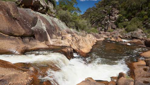
Bushwalkers are drawn to the pristine Kowmung River - a wild river that has inspired generations of walkers.
Flowing through the heart of the Kanangra-Boyd Wilderness, the Kowmung is the most loved wild river in the Blue Mountains. It rises on the Great Dividing Range and meets the Coxs River just before it enters Lake Burragorang.
Consultation related to the Critical State Significant Infrastructure (CSSI) declaration for the Warragamba Dam wall raising proposal
A consultation notice was released on 21 November 2022 in relation to the declaration in October 2022 of the project as Critical State Significant Infrastructure. The consultation documents include:
- Statement of reasons for the CSSI declaration (1 page)
- Preferred Infrastructure Report (886 pages)
- Government response to the submissions made to the EIS in late 2021 (869 pages)
You can let the NSW Government know what you think about the proposal through either:
- Through the "Give a Dam" campaign website (managed by Wilderness Australia and supported by the Society), or
- directly through the State Goverment's major projects online response form
The Environmental Impact Statement
The Environmental Impact Statement (EIS) was released on 29 September 2021.
Submissions closed on Sunday 19 December 2021. Here is the Society's submission.
Only 2% of the 2,067 submissions made to the EIS consultation supported the proposal.
The ABC reported that NSW's Blue Mountains could lose World Heritage status if the raising of the Warragamba Dam wall goes ahead.
Media
Here are some articles about the EIS and the wall raising.
- 21 October 2022 - Blue Mountains Conservation Society responds to NSW Premier's dam wall raising plans
Blue Mountains Gazette article - 6 October 2021 - Warragamba Dam wall-raising proposal impact statement released
Blue Mountains Gazette article - 5 October 2021 - NSW Coalition members urge alternatives to raising Warragamba Dam wall
Sydney Morning Herald article (and as a pdf) - 30 September 2021 - Warragamba Dam's EIS shows New South Wales government's efforts to avoid compensation
ABC News article (and as a pdf) - 29 September 2021 - Warragamba Dam EIS release next step in farcical process
Colong Foundation for Wilderness press release (and as a pdf) - 29 September 2021 - ‘Grossly under-playing’: Dam’s impact to UNESCO area differs from leaked report
Sydney Morning Herald article (and as a pdf) - 28 September 2021 - ‘Important UNESCO obligations’: Minister refuses to declare Warragamba wall-raising critical
Sydney Morning Herald article (and as a pdf) - 18 September 2020 - Damning federal government report on Warragamba Dam plan
Blue Mountains Gazette article - 14 February 2020 - Latest flooding has experts questioning Warragamba Dam wall raising plan
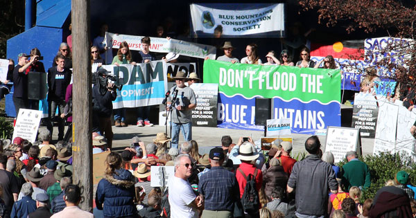
Blue Mountains Gazette article - 10 June 2019 - Hundreds protest in Katoomba at raising of Warragamba Dam wall
Blue Mountains Gazette article
Warragamba Dam
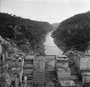 Warragamba Dam under construction
More than a century and many droughts later, work finally started in 1948 to build a reliable new water supply for Sydney's growing population.
It took 12 years and 1,800 workers to build the dam, which opened in 1960. It was such a major undertaking that a town was built next to the site to house the dam builders.
(population of Sydney in 1947 was 1.6 million; it is now 5 million)
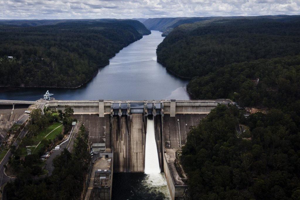
Holding over four times the capacity of Sydney Harbour, Lake Burragorang is the source of almost 70% of Sydney's drinking water.
In the late 1980s the dam wall was strengthened and raised by five metres.
 Warragamba Dam
Dam Wall: Length 351m; Thickness of base104m; Concrete mass 3000000t
Lake: Area 75km2; Length of lake 52km; Length of foreshores 354km; Maximum depth of reservoir 105m
Catchment: Catchment area 9,051km2; Annual average rainfall 840mm.
The building of Warragamba Dam - Sydney Catchment Authority
Traditional Owners
Mirragan and Gurangatch
A local Gundungurra Aboriginal creation story tells of two dreamtime spirits Mirragan - a large tiger cat, and his quarry Gurangatch - a part fish part reptile who lived in a lagoon where the Wollondilly and Wingecarribee Rivers meet.
During a long cross-country battle in the Dreaming (Gunyungalung), the deep gorges of the Burragorang Valley were gouged out.
It was this valley that was flooded when Warragamba Dam was built.
The Gundungurra
The Gundungurra traditional owners resisted the taking of their lands and, relying on various laws of the colony at the time, continually applied for official ownership.
Although their individual claims failed, in some kind of recognition of the significance of the designated tracts of land claimed, six Aboriginal Reserves (under the control of the NSW Aborigines Protection Board) were formally declared in the Burragorang Valley.
Even after these reserves were revoked, many of the traditional owners remained, quietly refusing to leave their traditional homelands.
Finally pushed into The Gully, a fringe development in West Katoomba from about 1894, the Gully community stayed together for more than 60 years. They were then dispossessed of the Gully by the then Blue Mountains Shire Council so that a group of local businessmen could develop a speedway that became known as the Catalina Race Track.
The Gully people kept talking about areas of land they had walked in as children - the nearby Megalong and Kanimbla Valleys and the Burragorang Valley. They knew of the profound significance of these valleys for their parents and grandparents.
The Gully was declared an Aboriginal Place on 18 May 2002. It became the largest Aboriginal Place in NSW.
The Impact
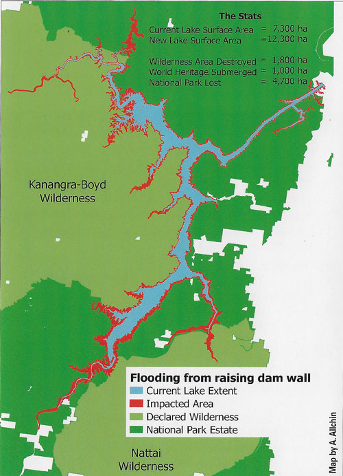 The Inundation
Raising Warragamba Dam Wall
The dam wall has already been raised and a spillway constructed to make the dam safe from any flood.
What is proposed now would increase the dam's storage capacity by another 50% or enough storage to fill Sydney Harbour twice.
12 metre spillway causes the most damage
A higher spillway will hold all small and medium floods behind the dam wall for several weeks. The submerged vegetation will die, leaving a scarred landscape of silt and dead trees to be infested by weeds after the waters subside.
Famous Blue Mountains World Heritage listed wild rivers will be ruined. The denuded area shown below is revealed when water levels in the dam are low.
Raising the dam wall will push this tidemark of degradation many kilometres upstream into spectacular wilderness valleys.
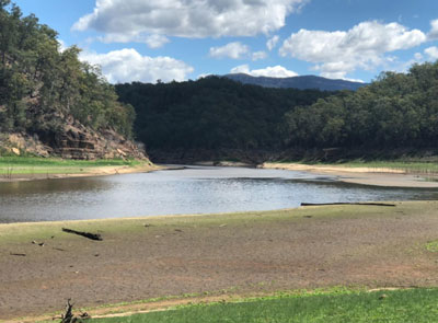 Denuded Area (Kazan Brown)
A future government could easily use the raised dam wall to hold water permanently and increase Sydney water storage.
The Impact
Current Lake Surface Area - 7,300ha
New Lake Surface Area - 12,300ha
Wilderness Area Destroyed - 1,800ha
World Heritage Submerged - 1,000ha
National Parks Lost - 4,700ha
Adverse Impacts
- Fragments and degrades two World Heritage list wilderness national parks
- Degrades world famous scenery of the southern Blue Mountains
- Reduces rare biodiversity, including 40% of the Nationally threatened Camden White Gum forest
- Aboriginal cultural heritage destroyed
- Loss of classic bushwalking areas, historic campsites drowned and access restricted
- Further urban sprawl on the floodplain and degradation to the Hawkesbury-Nepean River.
A better solution is to lower the full supply level for flood mitigation. This provides most of the benefits of the proposed dam wall raising and respects our international obligations to protect World Heritage.
We acknowledge the traditional custodians of this land
the Darug and Gundungurra people
and pay respect to their Elders past and present.